| at: |
DeSoto National Forest - Chickasawhay District |
Data from USFS GIS
 show on map
 animate
Trail users:


Elevation Profile
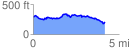
 4.228767 mi
 498.73 ft
 572.18 ft
 -73.45 ft
 2.56 %
GPX Downloads: Track Route
![]()
| at: |
DeSoto National Forest - Chickasawhay District |
show on map
animate
4.228767 mi
498.73 ft
572.18 ft
-73.45 ft
2.56 %