| at: |
DeSoto National Forest - Chickasawhay District |
Data from USFS GIS
 show on map
 animate
Trail users:


Elevation Profile
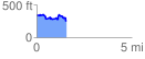
 1.572532 mi
 182.63 ft
 289.24 ft
 -106.61 ft
 3.48 %
GPX Downloads: Track Route
![]()
| at: |
DeSoto National Forest - Chickasawhay District |
show on map
animate
1.572532 mi
182.63 ft
289.24 ft
-106.61 ft
3.48 %