|
| at: |
DeSoto National Forest - Chickasawhay District |
Data from USFS GIS
 show on map
 animate
Trail users:


Elevation Profile
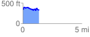
 1.359528 mi
 203.61 ft
 211.98 ft
 -8.37 ft
 2.95 %
GPX Downloads: Track Route
![]()
|
| at: |
DeSoto National Forest - Chickasawhay District |
show on map
animate
1.359528 mi
203.61 ft
211.98 ft
-8.37 ft
2.95 %