| at: |
DeSoto National Forest - Chickasawhay District |
Data from USFS GIS
 show on map
 animate
Trail users:


Elevation Profile
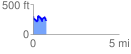
 0.774687 mi
 207.46 ft
 256.61 ft
 -49.15 ft
 6.27 %
GPX Downloads: Track Route
![]()
| at: |
DeSoto National Forest - Chickasawhay District |
show on map
animate
0.774687 mi
207.46 ft
256.61 ft
-49.15 ft
6.27 %