| at: |
DeSoto National Forest - Chickasawhay District |
Data from USFS GIS
 show on map
 animate
Trail users:


Elevation Profile
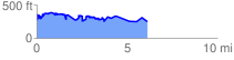
 6.335825 mi
 1497.12 ft
 1494.17 ft
 2.95 ft
 4.48 %
GPX Downloads: Track Route
![]()
| at: |
DeSoto National Forest - Chickasawhay District |
show on map
animate
6.335825 mi
1497.12 ft
1494.17 ft
2.95 ft
4.48 %