| at: |
DeSoto National Forest - Chickasawhay District |
Data from USFS GIS
 show on map
 animate
Trail users:


Elevation Profile
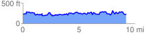
 9.575856 mi
 2546.83 ft
 2547.99 ft
 -1.16 ft
 5.04 %
GPX Downloads: Track Route
![]()
| at: |
DeSoto National Forest - Chickasawhay District |
show on map
animate
9.575856 mi
2546.83 ft
2547.99 ft
-1.16 ft
5.04 %