| at: |
DeSoto National Forest - Chickasawhay District |
Data from USFS GIS
 show on map
 animate
Trail users:

Elevation Profile
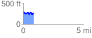
 0.870087 mi
 171.91 ft
 216.29 ft
 -44.38 ft
 4.71 %
GPX Downloads: Track Route
![]()
| at: |
DeSoto National Forest - Chickasawhay District |
show on map
animate
0.870087 mi
171.91 ft
216.29 ft
-44.38 ft
4.71 %