|
| at: |
DeSoto National Forest - South |
Data from USFS GIS
 show on map
 animate
Trail users:


Elevation Profile
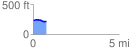
 0.753033 mi
 20.45 ft
 42.22 ft
 -21.77 ft
 1.06 %
GPX Downloads: Track Route
![]()
|
| at: |
DeSoto National Forest - South |
show on map
animate
0.753033 mi
20.45 ft
42.22 ft
-21.77 ft
1.06 %