| at: |
DeSoto National Forest - South |
Data from USFS GIS
 show on map
 animate
Trail users:


Elevation Profile
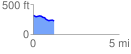
 1.217467 mi
 26.64 ft
 122.93 ft
 -96.29 ft
 1.91 %
GPX Downloads: Track Route
![]()
| at: |
DeSoto National Forest - South |
show on map
animate
1.217467 mi
26.64 ft
122.93 ft
-96.29 ft
1.91 %