| at: |
DeSoto National Forest - South |
Data from USFS GIS
 show on map
 animate
Trail users:


Elevation Profile
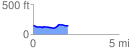
 2.050799 mi
 93.40 ft
 99.01 ft
 -5.62 ft
 0.91 %
GPX Downloads: Track Route
![]()
| at: |
DeSoto National Forest - South |
show on map
animate
2.050799 mi
93.40 ft
99.01 ft
-5.62 ft
0.91 %