| at: |
DeSoto National Forest - South |
Data from USFS GIS
 show on map
 animate
Trail users:


Elevation Profile
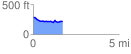
 1.742138 mi
 67.56 ft
 131.97 ft
 -64.42 ft
 1.43 %
GPX Downloads: Track Route
![]()
| at: |
DeSoto National Forest - South |
show on map
animate
1.742138 mi
67.56 ft
131.97 ft
-64.42 ft
1.43 %