| at: |
DeSoto National Forest - South |
Data from USFS GIS
 show on map
 animate
Trail users:


Elevation Profile
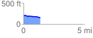
 1.398157 mi
 14.47 ft
 72.52 ft
 -58.05 ft
 0.98 %
GPX Downloads: Track Route
![]()
| at: |
DeSoto National Forest - South |
show on map
animate
1.398157 mi
14.47 ft
72.52 ft
-58.05 ft
0.98 %