| at: |
DeSoto National Forest - South |
Data from USFS GIS
 show on map
 animate
Trail users:


Elevation Profile
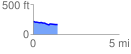
 1.412409 mi
 18.93 ft
 73.29 ft
 -54.35 ft
 0.98 %
GPX Downloads: Track Route
![]()
| at: |
DeSoto National Forest - South |
show on map
animate
1.412409 mi
18.93 ft
73.29 ft
-54.35 ft
0.98 %