| at: |
DeSoto National Forest - South |
Data from USFS GIS
 show on map
 animate
Trail users:


Elevation Profile
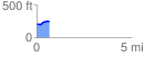
 0.677004 mi
 50.05 ft
 17.82 ft
 32.23 ft
 1.40 %
GPX Downloads: Track Route
![]()
| at: |
DeSoto National Forest - South |
show on map
animate
0.677004 mi
50.05 ft
17.82 ft
32.23 ft
1.40 %