|
| at: |
DeSoto National Forest - South |
Data from USFS GIS
 show on map
 animate
Trail users:


Elevation Profile
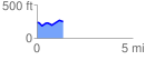
 1.372394 mi
 119.63 ft
 112.19 ft
 7.45 ft
 1.65 %
GPX Downloads: Track Route
![]()
|
| at: |
DeSoto National Forest - South |
show on map
animate
1.372394 mi
119.63 ft
112.19 ft
7.45 ft
1.65 %