| at: |
DeSoto National Forest - South |
Data from USFS GIS
 show on map
 animate
Trail users:


Elevation Profile
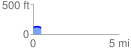
 0.498161 mi
 27.25 ft
 24.36 ft
 2.89 ft
 1.04 %
GPX Downloads: Track Route
![]()
| at: |
DeSoto National Forest - South |
show on map
animate
0.498161 mi
27.25 ft
24.36 ft
2.89 ft
1.04 %