| at: |
DeSoto National Forest - South |
Data from USFS GIS
 show on map
 animate
Trail users:


Elevation Profile
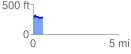
 0.576245 mi
 58.72 ft
 48.95 ft
 9.77 ft
 1.93 %
GPX Downloads: Track Route
![]()
| at: |
DeSoto National Forest - South |
show on map
animate
0.576245 mi
58.72 ft
48.95 ft
9.77 ft
1.93 %