|
| at: |
DeSoto National Forest - South |
Data from USFS GIS
 show on map
 animate
Trail users:


Elevation Profile
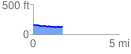
 1.854827 mi
 58.36 ft
 93.72 ft
 -35.36 ft
 0.96 %
GPX Downloads: Track Route
![]()
|
| at: |
DeSoto National Forest - South |
show on map
animate
1.854827 mi
58.36 ft
93.72 ft
-35.36 ft
0.96 %