| at: |
DeSoto National Forest - South |
Data from USFS GIS
 show on map
 animate
Trail users:


Elevation Profile
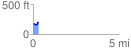
 0.339502 mi
 47.66 ft
 18.09 ft
 29.57 ft
 2.66 %
GPX Downloads: Track Route
![]()
| at: |
DeSoto National Forest - South |
show on map
animate
0.339502 mi
47.66 ft
18.09 ft
29.57 ft
2.66 %