|
| at: |
DeSoto National Forest - South |
Data from USFS GIS
 show on map
 animate
Trail users:


Elevation Profile
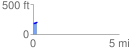
 0.241321 mi
 19.37 ft
 1.43 ft
 17.94 ft
 1.52 %
GPX Downloads: Track Route
![]()
|
| at: |
DeSoto National Forest - South |
show on map
animate
0.241321 mi
19.37 ft
1.43 ft
17.94 ft
1.52 %