| at: |
DeSoto National Forest - South |
Data from USFS GIS
 show on map
 animate
Trail users:


Elevation Profile
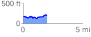
 2.056609 mi
 199.34 ft
 161.22 ft
 38.12 ft
 1.84 %
GPX Downloads: Track Route
![]()
| at: |
DeSoto National Forest - South |
show on map
animate
2.056609 mi
199.34 ft
161.22 ft
38.12 ft
1.84 %