| at: |
DeSoto National Forest - South |
Data from USFS GIS
 show on map
 animate
Trail users:


Elevation Profile
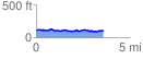
 3.652009 mi
 146.21 ft
 164.29 ft
 -18.08 ft
 0.85 %
GPX Downloads: Track Route
![]()
| at: |
DeSoto National Forest - South |
show on map
animate
3.652009 mi
146.21 ft
164.29 ft
-18.08 ft
0.85 %