|
| at: |
DeSoto National Forest - South |
Data from USFS GIS
 show on map
 animate
Trail users:


Elevation Profile
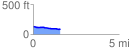
 1.594998 mi
 15.86 ft
 66.09 ft
 -50.23 ft
 0.78 %
GPX Downloads: Track Route
![]()
|
| at: |
DeSoto National Forest - South |
show on map
animate
1.594998 mi
15.86 ft
66.09 ft
-50.23 ft
0.78 %