|
| at: |
DeSoto National Forest - South |
Data from USFS GIS
 show on map
 animate
Trail users:


Elevation Profile
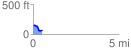
 0.539686 mi
 21.75 ft
 104.86 ft
 -83.11 ft
 3.68 %
GPX Downloads: Track Route
![]()
|
| at: |
DeSoto National Forest - South |
show on map
animate
0.539686 mi
21.75 ft
104.86 ft
-83.11 ft
3.68 %