| at: |
DeSoto National Forest - South |
Data from USFS GIS
 show on map
 animate
Trail users:


Elevation Profile
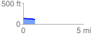
 0.967615 mi
 19.41 ft
 41.95 ft
 -22.53 ft
 0.82 %
GPX Downloads: Track Route
![]()
| at: |
DeSoto National Forest - South |
show on map
animate
0.967615 mi
19.41 ft
41.95 ft
-22.53 ft
0.82 %