|
| at: |
DeSoto National Forest - South |
Data from USFS GIS
 show on map
 animate
Trail users:


Elevation Profile
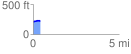
 0.424114 mi
 24.18 ft
 15.06 ft
 9.12 ft
 1.08 %
GPX Downloads: Track Route
![]()
|
| at: |
DeSoto National Forest - South |
show on map
animate
0.424114 mi
24.18 ft
15.06 ft
9.12 ft
1.08 %