| at: |
DeSoto National Forest - South |
Data from USFS GIS
 show on map
 animate
Trail users:


Elevation Profile
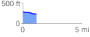
 1.168758 mi
 5.64 ft
 74.59 ft
 -68.96 ft
 1.21 %
GPX Downloads: Track Route
![]()
| at: |
DeSoto National Forest - South |
show on map
animate
1.168758 mi
5.64 ft
74.59 ft
-68.96 ft
1.21 %