| at: |
DeSoto National Forest - South |
Data from USFS GIS
 show on map
 animate
Trail users:


Elevation Profile
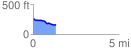
 1.338519 mi
 25.65 ft
 119.16 ft
 -93.52 ft
 1.69 %
GPX Downloads: Track Route
![]()
| at: |
DeSoto National Forest - South |
show on map
animate
1.338519 mi
25.65 ft
119.16 ft
-93.52 ft
1.69 %