| at: |
DeSoto National Forest - South |
Data from USFS GIS
 show on map
 animate
Trail users:


Elevation Profile
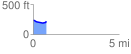
 0.791164 mi
 30.94 ft
 48.24 ft
 -17.30 ft
 1.15 %
GPX Downloads: Track Route
![]()
| at: |
DeSoto National Forest - South |
show on map
animate
0.791164 mi
30.94 ft
48.24 ft
-17.30 ft
1.15 %