|
| at: |
DeSoto National Forest - South |
Data from USFS GIS
 show on map
 animate
Trail users:


Elevation Profile
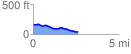
 2.630791 mi
 74.73 ft
 189.39 ft
 -114.66 ft
 1.36 %
GPX Downloads: Track Route
![]()
|
| at: |
DeSoto National Forest - South |
show on map
animate
2.630791 mi
74.73 ft
189.39 ft
-114.66 ft
1.36 %