|
| at: |
DeSoto National Forest - South |
Data from USFS GIS
 show on map
 animate
Trail users:


Elevation Profile
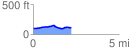
 2.226093 mi
 90.83 ft
 72.71 ft
 18.12 ft
 0.77 %
GPX Downloads: Track Route
![]()
|
| at: |
DeSoto National Forest - South |
show on map
animate
2.226093 mi
90.83 ft
72.71 ft
18.12 ft
0.77 %