| at: |
DeSoto National Forest - South |
Data from USFS GIS
 show on map
 animate
Trail users:


Elevation Profile
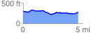
 4.617508 mi
 181.61 ft
 205.14 ft
 -23.53 ft
 0.84 %
GPX Downloads: Track Route
![]()
| at: |
DeSoto National Forest - South |
show on map
animate
4.617508 mi
181.61 ft
205.14 ft
-23.53 ft
0.84 %