|
| at: |
DeSoto National Forest - South |
Data from USFS GIS
 show on map
 animate
Trail users:


Elevation Profile
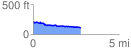
 2.796439 mi
 91.52 ft
 194.89 ft
 -103.37 ft
 1.32 %
GPX Downloads: Track Route
![]()
|
| at: |
DeSoto National Forest - South |
show on map
animate
2.796439 mi
91.52 ft
194.89 ft
-103.37 ft
1.32 %