| at: |
DeSoto National Forest - South |
Data from USFS GIS
 show on map
 animate
Trail users:


Elevation Profile
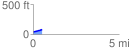
 0.531430 mi
 41.42 ft
 6.50 ft
 34.93 ft
 1.48 %
GPX Downloads: Track Route
![]()
| at: |
DeSoto National Forest - South |
show on map
animate
0.531430 mi
41.42 ft
6.50 ft
34.93 ft
1.48 %