|
| at: |
DeSoto National Forest - South |
Data from USFS GIS
 show on map
 animate
Trail users:


Elevation Profile
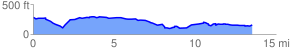
 13.868506 mi
 543.58 ft
 707.17 ft
 -163.59 ft
 0.97 %
GPX Downloads: Track Route
![]()
|
| at: |
DeSoto National Forest - South |
show on map
animate
13.868506 mi
543.58 ft
707.17 ft
-163.59 ft
0.97 %