|
| at: |
DeSoto National Forest - South |
Data from USFS GIS
 show on map
 animate
Trail users:


Elevation Profile
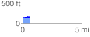
 0.607747 mi
 26.33 ft
 25.52 ft
 0.81 ft
 0.82 %
GPX Downloads: Track Route
![]()
|
| at: |
DeSoto National Forest - South |
show on map
animate
0.607747 mi
26.33 ft
25.52 ft
0.81 ft
0.82 %