| at: |
DeSoto National Forest - South |
Data from USFS GIS
 show on map
 animate
Trail users:


Elevation Profile
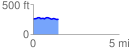
 1.470596 mi
 70.76 ft
 61.17 ft
 9.59 ft
 0.91 %
GPX Downloads: Track Route
![]()
| at: |
DeSoto National Forest - South |
show on map
animate
1.470596 mi
70.76 ft
61.17 ft
9.59 ft
0.91 %