|
| at: |
DeSoto National Forest - South |
Data from USFS GIS
 show on map
 animate
Trail users:


Elevation Profile
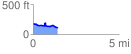
 1.430804 mi
 125.83 ft
 204.47 ft
 -78.64 ft
 2.71 %
GPX Downloads: Track Route
![]()
|
| at: |
DeSoto National Forest - South |
show on map
animate
1.430804 mi
125.83 ft
204.47 ft
-78.64 ft
2.71 %