| at: |
DeSoto National Forest - South |
Data from USFS GIS
 show on map
 animate
Trail users:


Elevation Profile
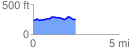
 2.479604 mi
 133.31 ft
 115.92 ft
 17.39 ft
 1.02 %
GPX Downloads: Track Route
![]()
| at: |
DeSoto National Forest - South |
show on map
animate
2.479604 mi
133.31 ft
115.92 ft
17.39 ft
1.02 %