| at: |
DeSoto National Forest - South |
Data from USFS GIS
 show on map
 animate
Trail users:


Elevation Profile
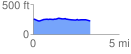
 3.319272 mi
 77.06 ft
 101.21 ft
 -24.15 ft
 0.58 %
GPX Downloads: Track Route
![]()
| at: |
DeSoto National Forest - South |
show on map
animate
3.319272 mi
77.06 ft
101.21 ft
-24.15 ft
0.58 %