| at: |
DeSoto National Forest - South |
Data from USFS GIS
 show on map
 animate
Trail users:


Elevation Profile
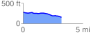
 3.239356 mi
 31.43 ft
 153.80 ft
 -122.37 ft
 0.90 %
GPX Downloads: Track Route
![]()
| at: |
DeSoto National Forest - South |
show on map
animate
3.239356 mi
31.43 ft
153.80 ft
-122.37 ft
0.90 %