|
| at: |
DeSoto National Forest - South |
Data from USFS GIS
 show on map
 animate
Trail users:


Elevation Profile
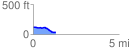
 1.300987 mi
 18.20 ft
 110.48 ft
 -92.28 ft
 1.61 %
GPX Downloads: Track Route
![]()
|
| at: |
DeSoto National Forest - South |
show on map
animate
1.300987 mi
18.20 ft
110.48 ft
-92.28 ft
1.61 %