|
| at: |
DeSoto National Forest - South |
Data from USFS GIS
 show on map
 animate
Trail users:


Elevation Profile
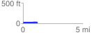
 1.216676 mi
 16.45 ft
 9.75 ft
 6.71 ft
 0.26 %
GPX Downloads: Track Route
![]()
|
| at: |
DeSoto National Forest - South |
show on map
animate
1.216676 mi
16.45 ft
9.75 ft
6.71 ft
0.26 %