| at: |
DeSoto National Forest - South |
Data from USFS GIS
 show on map
 animate
Trail users:


Elevation Profile
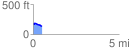
 0.541112 mi
 17.55 ft
 61.17 ft
 -43.63 ft
 2.14 %
GPX Downloads: Track Route
![]()
| at: |
DeSoto National Forest - South |
show on map
animate
0.541112 mi
17.55 ft
61.17 ft
-43.63 ft
2.14 %