| at: |
DeSoto National Forest - South |
Data from USFS GIS
 show on map
 animate
Trail users:


Elevation Profile
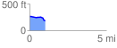
 1.018876 mi
 11.32 ft
 92.78 ft
 -81.46 ft
 1.72 %
GPX Downloads: Track Route
![]()
| at: |
DeSoto National Forest - South |
show on map
animate
1.018876 mi
11.32 ft
92.78 ft
-81.46 ft
1.72 %