| at: |
Bethel Trails DeSoto National Forest - South |
Data from USFS GIS
 show on map
 animate
Trail users:


Elevation Profile
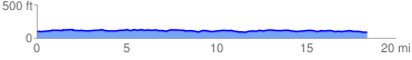
 18.621368 mi
 844.95 ft
 844.95 ft
 0.00 ft
 0.86 %
GPX Downloads: Track Route
![]()
| at: |
Bethel Trails DeSoto National Forest - South |
show on map
animate
18.621368 mi
844.95 ft
844.95 ft
0.00 ft
0.86 %