| at: |
DeSoto National Forest - South |
Data from USFS GIS
 show on map
 animate
Trail users:

Elevation Profile
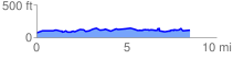
 8.733696 mi
 569.62 ft
 512.14 ft
 57.48 ft
 1.24 %
GPX Downloads: Track Route
![]()
| at: |
DeSoto National Forest - South |
show on map
animate
8.733696 mi
569.62 ft
512.14 ft
57.48 ft
1.24 %