| at: |
Bethel Trails DeSoto National Forest - South |
Data from USFS GIS
 show on map
 animate
Trail users:


Elevation Profile
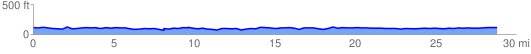
 29.374904 mi
 1493.64 ft
 1493.70 ft
 -0.06 ft
 0.96 %
GPX Downloads: Track Route
![]()
| at: |
Bethel Trails DeSoto National Forest - South |
show on map
animate
29.374904 mi
1493.64 ft
1493.70 ft
-0.06 ft
0.96 %