| at: |
Bethel Trails DeSoto National Forest - South |
Data from David Muse
 show on map
 animate
Trail users:


Elevation Profile
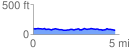
 4.787965 mi
 203.06 ft
 231.05 ft
 -27.99 ft
 0.91 %
GPX Downloads: Track Route
![]()
| at: |
Bethel Trails DeSoto National Forest - South |
show on map
animate
4.787965 mi
203.06 ft
231.05 ft
-27.99 ft
0.91 %