| at: |
Bethel Trails DeSoto National Forest - South |
Data from David Muse
 show on map
 animate
Trail users:


Elevation Profile
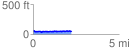
 2.223005 mi
 191.00 ft
 198.58 ft
 -7.58 ft
 1.69 %
GPX Downloads: Track Route
![]()
| at: |
Bethel Trails DeSoto National Forest - South |
show on map
animate
2.223005 mi
191.00 ft
198.58 ft
-7.58 ft
1.69 %